Western African Geography
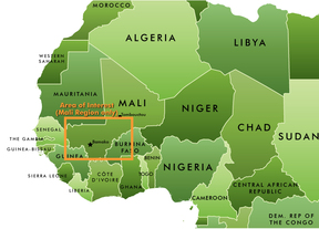
The West African region is mostly made up of Benin, Burkina Faso, Cape Verde, Côte d’Ivoire, The Gambia, Ghana, Guinea, Guinea-Bissau, Liberia, Mali, Mauritania, Niger, Nigeria, Senegal, Sierra Leone, and Togo. The western side of Chad can also be counted as part of Western Africa. The northern part of Mali, Mauritania, and Niger are the northern most areas of the region which turns very dry and arid due to the fact the Sahara Desert is North of the region. Cameroon is the southern border of West Africa. The Atlantic Ocean is the western border. The eastern border of the region is Lake Chad. So from west to east, the region is 2,500 miles. In other words, Western Africa is about the length of the United States.
Western Africa has a huge amount of unique geographical features. Most of the West African region is located on a plateau, so most of the region has a modest elevation. On the west coast of the region near Guinea, there is a forest that turns into a rain forest. It becomes a rain forest the farther south the forest goes. The eastern side of the region consists of the scrub vegetation. Scrub vegetation is small shrubs and desert grasses. In the southern part of the region, the geography of the land turns into high savanna grasslands. The north part of the region is a transitional zone to make way for the Sahara Desert.
Water in the northern part of West Africa is very rare. In the north part, the only water sources are the Niger River which is not very far north or Lake Chad which is very far inland. The Atlantic coastal area has large number of water systems. The Mauritanian-Senegal Basin is the largest water basin in West Africa. The Mauritanian-Senegal Basin collects water from the Senegal River, the Niger River, and the Volta River. All of the water in the Guinea Highlands also goes to the Mauritanian-Senegal Basin. There are also smaller basins on the east half of the region, but none as large as the Mauritanian-Senegal Basin.
